


Flood Alerts and Safety Measures in British Columbia Amid Intense Rainfall
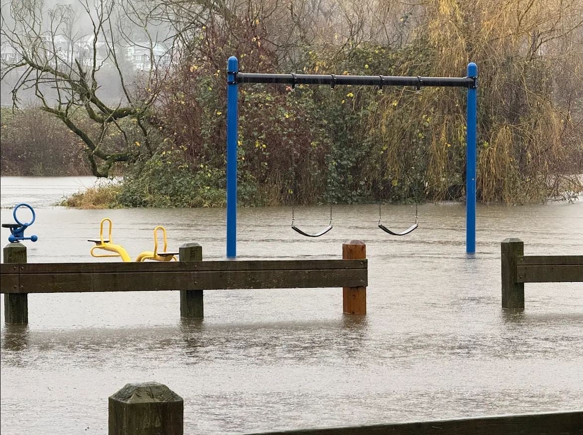
Heavy rainfall has left the parking lot and picnic zones at Hougen Park, near McKay Creek Trail Park in Abbotsford, B.C., submerged under water.
Widespread Flood Advisories in Southwest British Columbia
The River Forecast Center of British Columbia has issued flood alerts for several critical river basins including the Sumas River, Lower Fraser, and Skagit regions.These waterways are currently vulnerable due to persistent heavy precipitation.
- An atmospheric river event is delivering up to 130 millimeters of rain within a condensed timeframe across the area.
- Concerns persist over potential flooding from Washington State’s Nooksack River, which played a significant role during the devastating floods that struck this region in late 2021.
- While forecasts do not predict flooding on the scale seen previously, officials warn that sudden intensification of rainfall could still trigger severe conditions.
Coordinated Emergency Actions and Community Readiness
distribution of Sandbags Bolsters Flood Defenses
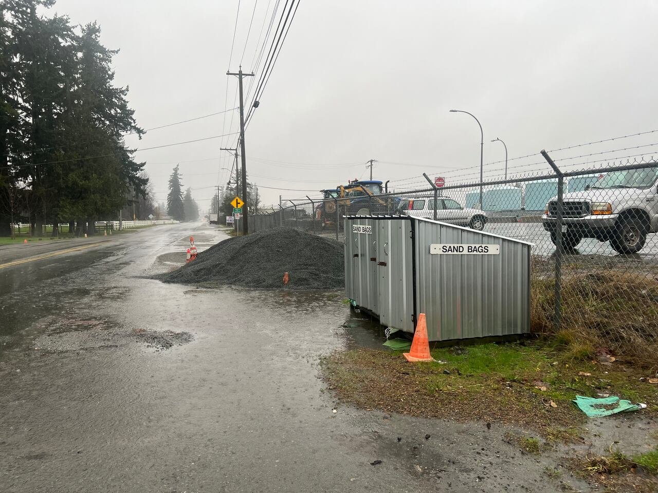
The City of Abbotsford has activated its Emergency Operations Centre to vigilantly track river levels, snowmelt contributions, and dike conditions. Collaboration with provincial agencies ensures timely management decisions such as operating the Barrowtown Pump Station efficiently. Residents are encouraged to collect sandbags from designated points as precautionary measures continue amid increasing water levels.
Evacuation Notices Issued Along Chilliwack River Corridor

The fraser Valley Regional District declared a local state of emergency due to escalating flood threats along the Chilliwack River valley. Immediate evacuation orders have been issued for eight homes on Wilson Road facing imminent inundation risks.Additionally, twelve properties along Chilliwack Lake Road received evacuation alerts advising residents to prepare for swift relocation if necessary. The Chilliwack River feeds into the larger Fraser system and remains under continuous observation by emergency teams.
Nooksack River: A Key Area Under Close Surveillance
The Nooksack River across Washington State continues drawing attention because of its past impact during atmospheric river events. Current readings indicate water levels approaching approximately 146.3 feet at Everson-a known overflow site-with projections estimating peaks near 148.5 feet within days.This remains below record highs exceeding 150 feet recorded during December’s catastrophic floods four years ago when thousands were displaced on both sides of the border.
Although experts consider it unlikely that these extreme heights will be matched this season, ongoing monitoring is vital given unpredictable whether patterns intensified by climate change effects influencing Pacific Northwest hydrology dynamics.
Meteorological Overview: Rainfall Expected to Peak this Afternoon
Meteorologists forecast that precipitation rates will reach their highest late this afternoon through early evening-periods when intense downpour could worsen vulnerabilities in flood-prone communities throughout southern B.C.. Recent climatological analyses reveal atmospheric rivers have increased in frequency by nearly 25 percent as early last decade,a trend linked directly with warmer ocean temperatures fueling more moisture-rich storms crossing coastal areas with greater intensity than before.
B.C.’s Emergency Management Officials Stress Heightened Awareness Amid Changing Conditions
B.C.’s Minister responsible for emergency management emphasized ongoing initiatives incorporating lessons learned from previous disasters-including infrastructure reinforcements like upgraded dikes around Sumas areas-and improved communication systems enabling faster deployment of resources such as pumps or barriers where urgently needed.“Communities affected previously remain vulnerable but better prepared,” she stated firmly while reminding residents living near low-lying zones about potential flooding risks primarily stemming from cross-border inflows via rivers like Nooksack.”
Transportation Challenges and Landslide Risks Highlighted by Authorities
- Caution advisories alert drivers about possible road washouts caused by saturated soils undermining key transportation routes connecting impacted towns;
- Landslide dangers rise significantly amid prolonged rainfall saturating slopes-especially where deforestation or construction activities have weakened natural buffers;
- Affected agencies continue updating forecasts regularly throughout evenings aiming at minimizing surprises through proactive public warnings;
Synthesizing Preparedness: Coordinated strategies Against Unpredictable Weather Events
This unfolding situation highlights how essential integrated forecasting combined with community readiness can reduce impacts posed by extreme weather phenomena amplified through global climate variability trends-particularly relevant here given recent precedents involving atmospheric rivers triggering widespread damage along western North America’s coastal corridors every few years rather than decades apart as observed historically.Residents are strongly urged not only to stay informed via official channels but also promptly utilize available protective resources such as locally distributed sandbags while remaining vigilant should further evacuations become necessary without delay .

